10 Postal Codes in San Marino
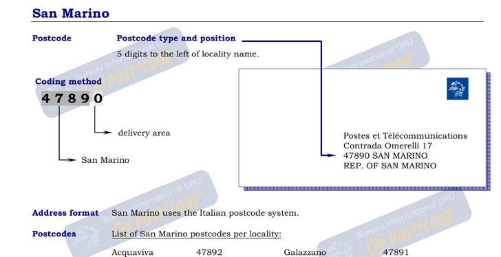
View a list of Postal Codes in San MarinoThe average area for postal codes in San Marino is 6.2 km² with the largest being 47893 in Borgo Maggiore at 9.8 km² and the smallest being 47898 in Cerbaiola, Montegiardino at 3.36 km². In San Marino the average population for a postal code is 3,151 with the most populated being postal code 47893 in Borgo Maggiore at 6,583. The average population density for a postal code in San Marino is 528 / km² with the densest being postal code 47891 in Serravalle (San Marino) at 1,304 / km². The median age for postal codes in San Marino ranges from 43.4 years old for 47891 in Serravalle (San Marino) to 43.5 years old for 47890 in Santa Mustiola. The fastest growing postal code is 47892 in Gualdicciolo, Acquaviva (San Marino) with population growth of 33.6% from 2000 to 2015, an average of 1.9% per year.
| Timezone | Central European Time |
| Area | 61.2 km² |
| Population | 31,477 |
| Population Density | 514 / km² |
| Postal Codes | 47890, 47891, 47892 (7 more) |
| Area Codes | 549 |
| Businesses in San Marino | 6,800 |
| Cities | 9 |
| Postal Code▲ | City↕ | Population↕ | Area |
|---|---|---|---|
| 47890 | Santa Mustiola | 3,889 | 6.5 km² |
| 47891 | Serravalle (San Marino) | 5,837 | 4.477 km² |
| 47892 | Gualdicciolo | 1,853 | 5 km² |
| 47893 | — | 6,583 | 9.8 km² |
| 47894 | — | 1,003 | 4.531 km² |
| 47895 | Domagnano | 3,388 | 6.8 km² |
| 47896 | Faetano | 1,450 | 9.4 km² |
| 47897 | Fiorentino | 2,047 | 6.9 km² |
| 47898 | Cerbaiola | 899 | 3.36 km² |
| 47899 | Fiorina (San Marino) | 4,561 | 5.1 km² |
Administration areas or states in San Marino
Most populated cities in San Marino
San Marino
San Marino (/sæn məˈriːnoʊ/; Italian: [sam maˈriːno]), officially the Republic of San Marino (Italian: Repubblica di San Marino), also known as the Most Serene Republic of San Marino (Italian: Serenissima Repubblica di San Marino), is an enclaved mic..
San Marino Wikipedia Page