476 Postal Codes in Costa Rica
View a list of Postal Codes in Costa RicaThe average area for postal codes in Costa Rica is 109.1 km² with the largest being 70404 in Limón Province at 2,220.3 km² and the smallest being 10802 in San Francisco de Dos Ríos, San José Province at 0.556 km². In Costa Rica the average population for a postal code is 10,225 with the most populated being postal code 10109 in Pavas, San José Province at 71,579. The average population density for a postal code in Costa Rica is 1,274 / km² with the densest being postal code 11304 in San José Province at 13,774 / km². The median age for postal codes in Costa Rica ranges from 18.0 years old for 30512 in Turrialba, Cartago Province to 38.2 years old for 10101 in Mata de Plátano, Cartago Province. The fastest growing postal code is 61101 in Jacó, Costa Rica, Puntarenas Province with population growth of 141.4% from 2000 to 2015, an average of 6.1% per year.
| Timezone | Central Standard Time |
| Area | 5,100 km² |
| Population | 4.5 million |
| Population Density | 886 / km² |
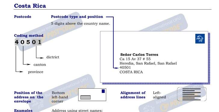
| Postal Codes | 00000, 00011, 08000 (473 more) |
| Businesses in Costa Rica | 346,165 |
| Cities | 161 |
| Postal Codes▲ | Administrative Region↕ | Number of postal codes↕ |
|---|---|---|
| 08000 - 20102 | San José Province | 121 |
| 20101 - 21504 | Alajuela Province | 113 |
| 30101 - 30804 | Cartago Province | 54 |
| 40101 - 41005 | Heredia Province | 46 |
| 50101 - 51104 | Guanacaste Province | 59 |
| 60101 - 61102 | Puntarenas Province | 56 |
| 70101 - 70605 | Limón Province | 28 |
Most populated cities in Costa Rica
Costa Rica
Rica (/ˌkɒstə ˈriːkə/; Spanish: [ˈkosta ˈrika]; literally meaning, "Rich Coast"), officially the Republic of Costa Rica (Spanish: República de Costa Rica), is a country in Central America, bordered by Nicaragua to the north, Panama to the southeast..
Costa Rica Wikipedia Page