176 Postal Codes in Zala County
View a list of Postal Codes in Zala County| Timezone | Central European Time |
| Area | 3,783 km² |
| Population | 263,853 (More Details) |
| Population Density | 69.7 / km² |
| Male Population | 125,697 (47.6%) |
| Female Population | 138,156 (52.4%) |
| Median Age | 43.8 |
| Postal Codes | 8313, 8314, 8315 (173 more) |
| Area Codes | 83, 92, 93 |
| Businesses in Zala County | 41,211 |
| Cities | 155 |
Postal Code Ranges
| Postal Codes▲ | City↕ | Number of postal codes↕ |
|---|---|---|
| 8360 - 8364 | Keszthely | 5 |
| 8800 - 8809 | Nagykanizsa | 7 |
| 8900 - 8909 | Zalaegerszeg | 10 |
| 8960 - 8966 | Lenti | 4 |
Interactive Map
176 Postal Codes in Zala County
| Postal Code▲ | City↕ | Population↕ | Area |
|---|---|---|---|
| 8313 | Balatongyörök | 937 | 37.4 km² |
| 8314 | Vonyarcvashegy | 1,954 | 14.4 km² |
| 8315 | Gyenesdiás | 3,063 | 18.6 km² |
| 8316 | Vállus | 1,070 | 46.6 km² |
| 8341 | Szalapa | 565 | 20.9 km² |
| 8342 | Óhíd | 568 | 12.5 km² |
| 8353 | Zalaszántó | 957 | 42.4 km² |
| 8354 | Karmacs | 882 | 20 km² |
| 8355 | Vindornyaszőlős | 343 | 10.6 km² |
| 8356 | Nagygörbő | 299 | 14 km² |
| 8357 | Döbröce | 649 | 20.1 km² |
| 8360 | Keszthely | 18,835 | 75.9 km² |
| 8361 | Keszthely | — | — |
| 8362 | Keszthely | — | — |
| 8363 | Keszthely | — | — |
| 8364 | Keszthely | — | — |
| 8371 | Nemesbük | 835 | 10 km² |
| 8372 | Cserszegtomaj | 3,245 | 12.6 km² |
| 8373 | Rezi | 1,352 | 29.7 km² |
| 8380 | Hévíz | 5,620 | 8.7 km² |
| 8381 | Felsőpáhok | — | — |
| 8391 | Sármellék | 1,989 | 34.5 km² |
| 8392 | Zalavár | 1,028 | 32 km² |
| 8393 | Szentgyörgyvár | 262 | 11.5 km² |
| 8394 | Alsópáhok | 1,602 | 17.8 km² |
Showing 1-25 of 176
…
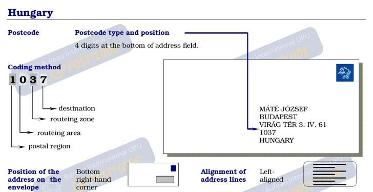
Address Example
Zala County Demographic Information
| Population | 263,853 |
| Population Density | 69.7 / km² |
| Male Population | 125,697 (47.6%) |
| Female Population | 138,156 (52.4%) |
| Median Age | 43.8 |
| Male Median Age | 40.8 |
| Female Median Age | 46.5 |
| Businesses in Zala County | 41,211 |
| Population (1975) | 488,338 |
| Population (2000) | 341,225 |
| Population change from 1975 to 2015 | -46.0% |
| Population change from 2000 to 2015 | -22.7% |
Most populated cities in Zala County
Zala County
Zala (Slovene: Zalska županija or županija Zala) is an administrative county (comitatus or megye) in south-western Hungary. It is named after the Zala River. It shares borders with Croatia and Slovenia and the Hungarian counties Vas, Veszprém and Som..
Zala County Wikipedia Page