487 Postal Codes in Aguascalientes
View a list of Postal Codes in Aguascalientes| Timezone | Central Standard Time |
| Area | 5,616 km² |
| Population | 1.4 million (More Details) |
| Population Density | 241 / km² |
| Male Population | 659,469 (48.7%) |
| Female Population | 695,741 (51.3%) |
| Median Age | 24.5 |
| Postal Codes | 02008, 20000, 20010 (484 more) |
| Area Codes | 346, 458, 467 (3 more) |
| Businesses in Aguascalientes | 144,546 |
| Cities | 35 |
Postal Code Ranges
| Postal Codes▲ | City↕ | Number of postal codes↕ |
|---|---|---|
| 20000 - 20399 | Aguascalientes City | 163 |
| 20300 - 20305, 20356 - 20358 | San Francisco de los Romo | 9 |
| 20400 - 20457 | Rincón de Romos | 28 |
| 20460 - 20472 | Cosío | 8 |
| 20503 - 20505, 20540 - 20545 | San Antonio de los Ríos | 4 |
| 20600 - 20659 | Tepezalá | 24 |
| 20660 - 20687 | Pabellón de Arteaga | 18 |
| 20708 - 20799 | Asientos Municipality | 48 |
| 20800 - 20892 | Calvillo | 30 |
| 20900 - 20997 | Jesús María | 42 |
Interactive Map
487 Postal Codes in Aguascalientes
| Postal Code▲ | City↕ | Population↕ | Area |
|---|---|---|---|
| 02008 | Aguascalientes City | — | — |
| 20000 | Aguascalientes City | 9,816 | 1.581 km² |
| 20010 | Aguascalientes City | 16,015 | 1.51 km² |
| 20016 | Aguascalientes City | 2,243 | 0.349 km² |
| 20018 | Aguascalientes City | 885 | 45,327 m² |
| 20020 | Aguascalientes City | 8,065 | 1.014 km² |
| 20029 | Aguascalientes City | 530 | 69,510 m² |
| 20030 | Aguascalientes City | 12,476 | 1.352 km² |
| 20040 | Aguascalientes City | 12,730 | 1.366 km² |
| 20046 | Aguascalientes City | — | — |
| 20049 | Aguascalientes City | 772 | 0.169 km² |
| 20050 | Aguascalientes City | 10,376 | 0.767 km² |
| 20059 | Aguascalientes City | 7,357 | 0.834 km² |
| 20060 | Aguascalientes City | 1,394 | 0.337 km² |
| 20064 | Aguascalientes City | 1,238 | 0.206 km² |
| 20070 | Aguascalientes City | 10,145 | 1.018 km² |
| 20078 | Aguascalientes City | 3,787 | 0.271 km² |
| 20080 | Aguascalientes City | 2,610 | 0.416 km² |
| 20089 | Aguascalientes City | 2,990 | 0.268 km² |
| 20100 | Aguascalientes City | 3,044 | 3.103 km² |
| 20110 | Aguascalientes City | 1,733 | 1.304 km² |
| 20115 | Aguascalientes City | 3,951 | 1.034 km² |
| 20116 | Aguascalientes City | 2,229 | 0.686 km² |
| 20117 | Aguascalientes City | 1,043 | 21,026 m² |
| 20118 | Aguascalientes City | 2,268 | 0.934 km² |
Showing 1-25 of 487
…
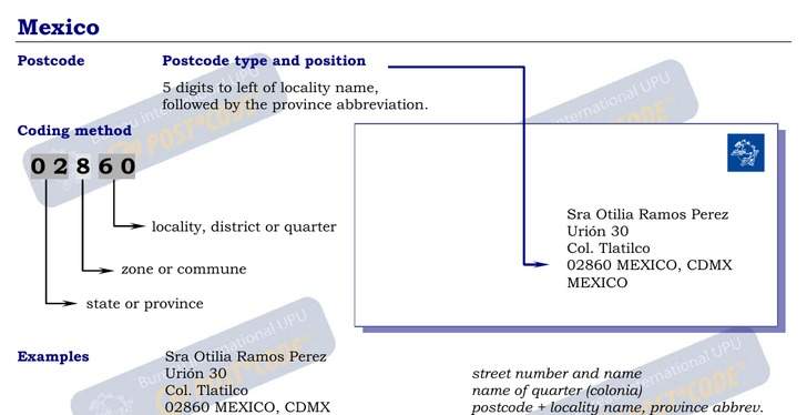
Address Example
Aguascalientes Demographic Information
| Population | 1.4 million |
| Population Density | 241 / km² |
| Male Population | 659,469 (48.7%) |
| Female Population | 695,741 (51.3%) |
| Median Age | 24.5 |
| Male Median Age | 23.6 |
| Female Median Age | 25.4 |
| Businesses in Aguascalientes | 144,546 |
| Population (1975) | 493,829 |
| Population (2000) | 1,030,821 |
| Population change from 1975 to 2015 | +174.4% |
| Population change from 2000 to 2015 | +31.5% |
Most populated cities in Aguascalientes
Aguascalientes
Aguascalientes ( ˈaɣwaskaˈljentes ), officially the Free and Sovereign State of Aguascalientes (Spanish: Estado Libre y Soberano de Aguascalientes, literally: Hot Waters), is one of the 31 states which, with the Federal District, comprise the 32 Fede..
Aguascalientes Wikipedia Page