1,028 Postal Codes in Durango
View a list of Postal Codes in Durango| Timezone | Central Standard Time |
| Area | 123,364 km² |
| Population | 1.8 million (More Details) |
| Population Density | 14.7 / km² |
| Male Population | 894,547 (49.2%) |
| Female Population | 922,600 (50.8%) |
| Median Age | 25.0 |
| Postal Codes | 27926, 34000, 34005 (1,025 more) |
| Area Codes | 346, 458, 467 (2 more) |
| Businesses in Durango | 112,972 |
| Cities | 52 |
Postal Code Ranges
| Postal Codes▲ | City↕ | Number of postal codes↕ |
|---|---|---|
| 34000 - 34398 | Durango City | 189 |
| 34400 - 34409, 34446 - 34467 | Ciudad Canatlán | 21 |
| 34410 - 34437 | Nuevo Ideal | 19 |
| 34470 - 34477 | Coneto de Comonfort | 6 |
| 34480 - 34485 | San Juan del Río | 4 |
| 34500 - 34537 | Canelas | 18 |
| 34540 - 34567 | Topia | 19 |
| 34580 - 34588 | Tamazula de Victoria | 8 |
| 34600 - 34617, 34630 - 34649 | Santiago Papasquiaro | 26 |
| 34670 - 34677, 34686 - 34696 | San Dimas Municipality | 12 |
| 34700 - 34713 | Guadalupe Victoria Municipality | 9 |
| 34740 - 34768 | Peñón Blanco | 18 |
| 34770 - 34795 | Pánuco de Coronado Municipality | 16 |
| 34840 - 34887 | Nombre de Dios | 24 |
| 34890 - 34895 | Vicente Guerrero | 5 |
| 34900 - 34927 | Súchil | 15 |
| 34940 - 34948 | El Salto | 6 |
| 35000 - 35147 | Gómez Palacio | 85 |
| 35233 - 35248 | Mapimí | 11 |
| 35250 - 35290 | Tlahualilo Municipality | 19 |
| 35350 - 35356 | Villa Ocampo | 4 |
| 35417 - 35447 | Guanaceví | 17 |
| 35500 - 35533 | Indé | 14 |
| 35550 - 35594 | San Pedro del Gallo | 21 |
| 35600 - 35627, 35645 - 35647 | Tepehuanes | 12 |
| 35690 - 35698 | Santa María del Oro | 7 |
| 35700 - 35737 | Nazas | 17 |
| 35760 - 35787 | Rodeo | 16 |
| 35800 - 35847 | Cuencamé | 27 |
| 35880 - 35896 | Santa Clara Municipality | 12 |
| 35900 - 35947 | San Juan de Guadalupe | 23 |
Showing 1-31 of 31
Interactive Map
1,028 Postal Codes in Durango
| Postal Code▲ | City↕ | Population↕ | Area |
|---|---|---|---|
| 27926 | Banco Nacional | 351 | 25.4 km² |
| 34000 | Durango City | 25,505 | 4.649 km² |
| 34005 | Durango City | 548 | 1,320 m² |
| 34008 | Durango City | 260 | 3,178 m² |
| 34009 | Durango City | 138 | 1,048 m² |
| 34010 | Durango City | 22,801 | 2.303 km² |
| 34014 | Durango City | 2,546 | 0.771 km² |
| 34015 | Durango City | 1,111 | 0.207 km² |
| 34016 | Durango City | 2,076 | 2.434 km² |
| 34017 | Durango City | 5,992 | 0.731 km² |
| 34018 | Durango City | — | — |
| 34019 | Durango City | 1,284 | 0.275 km² |
| 34020 | Durango City | 10,277 | 0.708 km² |
| 34024 | Durango City | — | — |
| 34027 | Durango City | 2,913 | 32,633 m² |
| 34028 | Durango City | 3,433 | 97,569 m² |
| 34029 | Durango City | 3,390 | 0.202 km² |
| 34030 | Durango City | 6,913 | 0.992 km² |
| 34037 | Durango City | — | — |
| 34038 | Durango City | 1,873 | 0.394 km² |
| 34039 | Durango City | 1,344 | 0.307 km² |
| 34040 | Durango City | 4,300 | 0.357 km² |
| 34043 | Durango City | 1,891 | 0.342 km² |
| 34045 | Durango City | 5,013 | 1.735 km² |
| 34046 | Durango City | 3,787 | 1.797 km² |
Showing 1-25 of 1028
…
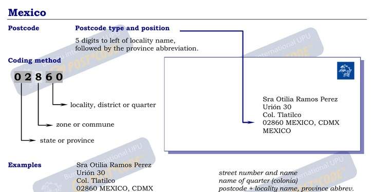
Address Example
Durango Demographic Information
| Population | 1.8 million |
| Population Density | 14.7 / km² |
| Male Population | 894,547 (49.2%) |
| Female Population | 922,600 (50.8%) |
| Median Age | 25.0 |
| Male Median Age | 24.2 |
| Female Median Age | 25.7 |
| Businesses in Durango | 112,972 |
| Population (1975) | 827,515 |
| Population (2000) | 1,501,755 |
| Population change from 1975 to 2015 | +119.6% |
| Population change from 2000 to 2015 | +21.0% |
Most populated cities in Durango
Durango
Durango ( duˈɾaŋɡo ), officially Free and Sovereign State of Durango (Spanish: Estado Libre y Soberano de Durango) ( Tepehuan: Korian) (Nahuatl: Tepēhuahcān), is one of the 31 states which, with the Federal District, compose the 32 Federal Entities o..
Durango Wikipedia Page