1 Postal Districts in Hunsel
View a list of Postal Districts in Hunsel| Timezone | Central European Time |
| Area | 6.5 km² |
| Population | 241 (More Details) |
| Male Population | 122 (50.6%) |
| Female Population | 119 (49.4%) |
| Median Age | 44.9 |
| Postal District | 6013 |
| Postal Codes | 34 |
| Area Codes | 475 |
Interactive Map
Hunsel Demographic Information
| Population | 241 |
| Population Density | 36.9 / km² |
| Male Population | 122 (50.6%) |
| Female Population | 119 (49.4%) |
| Median Age | 44.9 |
| Male Median Age | 44.3 |
| Female Median Age | 45.6 |
| Businesses in Hunsel | 293 |
| Population (1975) | 316 |
| Population (2000) | 226 |
| Population change from 1975 to 2015 | -23.7% |
| Population change from 2000 to 2015 | +6.6% |
Hunsel
Hunsel ( pronunciation ) is a town in the south-eastern Netherlands. it became a part of Leudal on 1 January 2007, Hunsel was a separate municipality, covering also the villages of Ell, Haler, Ittervoort and Neeritter
Hunsel Wikipedia Page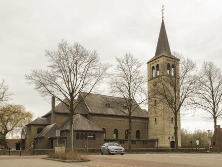
Nearby Cities
| City▲ | Administrative Region↕ | Country Or Region | City Population↕ | Postal Codes |
|---|---|---|---|---|
| Born, Netherlands | Limburg (Netherlands) | Netherlands | 97,169 | 6118, 6121, 6124, 6135, 6167 |
| Maaseik | Flanders | Belgium | 23,684 | 3910 |
| Roermond | Limburg (Netherlands) | Netherlands | 44,975 | 6041, 6042, 6043, 6044, 6045, 6071, 6074, 6075 |
| Sittard | Limburg (Netherlands) | Netherlands | 48,400 | 6131, 6132, 6133, 6134, 6135, 6136, 6137, 6162, 6167 |
| Weert | Limburg (Netherlands) | Netherlands | 48,662 | 6001, 6002, 6003, 6004, 6005, 6006 |