159 Postal Codes in Hedmark
View a list of Postal Codes in Hedmark| Timezone | Central European Time |
| Area | 27,410 km² |
| Population | 196,387 (More Details) |
| Population Density | 7.2 / km² |
| Male Population | 97,441 (49.6%) |
| Female Population | 98,946 (50.4%) |
| Median Age | 43.0 |
| Postal Codes | 2100, 2101, 2110 (156 more) |
| Area Codes | 62 |
| Businesses in Hedmark | 46,884 |
| Cities | 48 |
Postal Code Ranges
| Postal Codes▲ | City↕ | Number of postal codes↕ |
|---|---|---|
| 2201 - 2218 | Kongsvinger | 15 |
| 2301 - 2326 | Hamar | 20 |
| 2332 - 2336 | Stange | 3 |
| 2380 - 2389 | Brumunddal | 10 |
| 2401 - 2418 | Elverum | 12 |
| 2500 - 2510 | Tynset | 3 |
| 2540 - 2544 | Tolga, Norway | 2 |
Interactive Map
159 Postal Codes in Hedmark
| Postal Code▲ | City↕ | Population↕ | Area |
|---|---|---|---|
| 2100 | Skarnes | 4,731 | 134.5 km² |
| 2101 | Skarnes | — | — |
| 2110 | — | 432 | 62.2 km² |
| 2114 | Disenå | 1,412 | 158.7 km² |
| 2116 | Sander, Norway | 878 | 81.8 km² |
| 2120 | Sand, Hedmark | 2,678 | 154.6 km² |
| 2123 | — | 724 | 91.3 km² |
| 2130 | Knapper | 807 | 109.5 km² |
| 2133 | Knapper | 958 | 76.9 km² |
| 2134 | — | 145 | 89 km² |
| 2201 | Kongsvinger | — | — |
| 2202 | Kongsvinger | — | — |
| 2203 | Kongsvinger | — | — |
| 2204 | Kongsvinger | — | — |
| 2205 | Kongsvinger | — | — |
| 2206 | Kongsvinger | — | — |
| 2208 | Kongsvinger | 1,917 | 22.6 km² |
| 2209 | Kongsvinger | 996 | 3.395 km² |
| 2210 | — | 1,128 | 95.2 km² |
| 2211 | Kongsvinger | 4,402 | 52.3 km² |
| 2212 | Kongsvinger | 4,112 | 37.7 km² |
| 2213 | Kongsvinger | 1,117 | 21.7 km² |
| 2214 | Kongsvinger | 768 | 2.118 km² |
| 2216 | Roverud | 1,216 | 43.1 km² |
| 2217 | — | 229 | 61 km² |
Showing 1-25 of 159
…
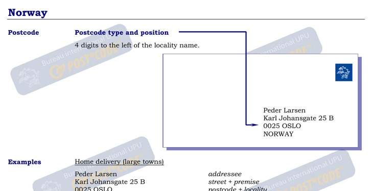
Address Example
Hedmark Demographic Information
| Population | 196,387 |
| Population Density | 7.2 / km² |
| Male Population | 97,441 (49.6%) |
| Female Population | 98,946 (50.4%) |
| Median Age | 43.0 |
| Male Median Age | 41.8 |
| Female Median Age | 44.1 |
| Businesses in Hedmark | 46,884 |
| Population (1975) | 197,335 |
| Population (2000) | 188,531 |
| Population change from 1975 to 2015 | -0.5% |
| Population change from 2000 to 2015 | +4.2% |
Most populated cities in Hedmark
Hedmark
Hedmark [ˈheːdˈmɑrk] ( listen) is a county in Norway, bordering Sør-Trøndelag to the north, Oppland to the west and Akershus to the south. The county administration is in Hamar. makes up the northeastern part of Østlandet, the southeastern part of ..
Hedmark Wikipedia Page