Postal Code 48653 - Coesfeld, North Rhine-Westphalia
| Primary City | Coesfeld |
| Area of Postal Code 48653 | 142 km² |
| Population | 36,558 |
| Male Population | 17,859 (48.9%) |
| Female Population | 18,699 (51.1%) |
| Population change from 1975 to 2020 | +11.3% |
| Population change from 2000 to 2020 | +1.5% |
| Median Age | 44.1 years |
| Male Median Age | 43.1 years |
| Female Median Age | 45.1 years |
| Area Codes | 2541, 2546 |
| Neighborhoods | Brink, Flamschen, Goxel, Harle, Lette, Stevede, Stockum |
| Timezone | Central European Summer Time |
| Coordinates | 51.91907595145039° / 7.152134885121023° |
| Related Postal Codes | 48527, 48529, 48565, 48607, 48612, 48619, 48624, 48629, 48683, 48691 |
Map of Postal Code 48653 - Coesfeld, North Rhine-Westphalia
Interactive Map
Postal Code 48653 - Coesfeld, North Rhine-Westphalia Population
Years 1975 to 2030
| Data | 1975 | 1990 | 2000 | 2015 | 2020 | 2025* | 2030* |
|---|---|---|---|---|---|---|---|
| Population | 32,855 | 34,153 | 36,014 | 36,186 | 36,558 | 36,115 | 35,597 |
| Population Density | 231.3 / km² | 240.4 / km² | 253.5 / km² | 254.8 / km² | 257.4 / km² | 254.3 / km² | 250.6 / km² |
Postal Code 48653 - Coesfeld, North Rhine-Westphalia Population change from 2000 to 2020
Increase of 1.5% from year 2000 to 2020
| Location | Change since 1975 | Change since 1990 | Change since 2000 |
|---|---|---|---|
| Postal Code 48653 - Coesfeld, North Rhine-Westphalia | +11.3% | +7% | +1.5% |
| Coesfeld | -3.9% | -0.9% | -0.2% |
| North Rhine-Westphalia | +6.8% | +6% | +2.2% |
| Germany | — | — | — |
Postal Code 48653 - Coesfeld, North Rhine-Westphalia Median Age
Median Age: 44.1 years
| Location | Median Age | Median Age (Female) | Median Age (Male) |
|---|---|---|---|
| Postal Code 48653 - Coesfeld, North Rhine-Westphalia | 44.1 yrs | 45.1 yrs | 43.1 yrs |
| Coesfeld | 44.1 yrs | 45.1 yrs | 43.1 yrs |
| North Rhine-Westphalia | 44.5 yrs | 45.6 yrs | 43.3 yrs |
| Germany | 44.8 yrs | 46 yrs | 43.6 yrs |
Postal Code 48653 Population Density
Population Density: 257 / km²
| Location | Population | Area | Density |
|---|---|---|---|
| Postal Code 48653 | 36,558 | 142 km² | 257 / km² |
| Coesfeld | 22,414 | 9.9 km² | 2,271 / km² |
| North Rhine-Westphalia | 18.3 million | 34,118.6 km² | 537 / km² |
| Germany | 80.7 million | 358,179.8 km² | 225 / km² |
Postal Code 48653 - Coesfeld, North Rhine-Westphalia Historical and Projected Population
Estimated Population from 200 to 2100
- JRC (European Commission's Joint Research Centre) work on the GHS built-up grid
- CIESIN (Center for International Earth Science Information Network)
- [Link] Klein Goldewijk, K., Beusen, A., Doelman, J., and Stehfest, E.: Anthropogenic land use estimates for the Holocene – HYDE 3.2, Earth Syst. Sci. Data, 9, 927–953, https://doi.org/10.5194/essd-9-927-2017, 2017.
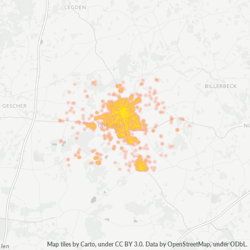
Neighborhoods
Business Distribution by neighborhood in Postal Code 48653 - Coesfeld, North Rhine-Westphalia
Area Codes
Percentage Area Codes used by businesses in Postal Code 48653 - Coesfeld, North Rhine-Westphalia
Industries
Business Distribution by Industry in Postal Code 48653 - Coesfeld, North Rhine-Westphalia
| Industry Description | Number of Establishments | Average Age of Business |
|---|---|---|
| Car repair | 70 | 42.8 years |
| Clothing stores | 85 | — |
| Construction of buildings | 119 | — |
| Corporate management | 173 | 26.8 years |
| Hairdressers | 65 | — |
| Health and medical | 162 | — |
| Other membership organizations | 65 | 46.2 years |
| Real estate | 128 | — |
| Restaurants | 128 | — |
| Shopping | 209 | — |
| Tractors and farm equipment | 76 | — |
Business distribution by price for Postal Code 48653 - Coesfeld, North Rhine-Westphalia
Human Development Index (HDI)
Statistic composite index of life expectancy, education, and per capita income.
Postal Code 48653 - Coesfeld, North Rhine-Westphalia Gross Domestic Product (GDP)
GDP per capita, PPP (constant 2017 international $)
| Data | 1990 | 1995 | 2000 | 2005 | 2010 | 2015 | 2020 | 2022 |
|---|---|---|---|---|---|---|---|---|
| GDP per capita | $27,026 | $28,957 | $31,584 | $31,764 | $33,153 | $36,496 | $38,845 | $40,437 |
| Total GDP | $520.5M | $577.7M | $646.2M | $652.6M | $687.7M | $767.6M | $811.5M | $845.7M |
Postal Code 48653 CO2 Emissions
Carbon Dioxide (CO2) Emissions Per Capita in Tonnes Per Year
| Location | CO2 Emissions | CO2 Emissions Per Capita | CO2 Emissions Intensity |
|---|---|---|---|
| Postal Code 48653 | 373,250 tn | 10.21 tn | 2,627.8 tons/km² |
| Coesfeld | 228,277 tn | 10.18 tn | 23,128.3 tons/km² |
| North Rhine-Westphalia | 183,519,420 tn | 10.01 tn | 5,378.9 tons/km² |
| Germany | 755,339,039 tn | 9.36 tn | 2,108.8 tons/km² |
| 2013 CO2 emissions (tonnes/year) | 373,250 tn |
| 2013 CO2 emissions (tonnes/year) per capita | 10.21 tn |
| 2013 CO2 emissions intensity (tonnes/km²/year) | 2,627.8 tons/km² |
Natural Hazards Risk
Relative risk out of 10
| Hazard | Risk Level |
|---|---|
| Flood | Medium (7) |
Recent Nearby Earthquakes
Magnitude 3.0 and greater
| Date▼ | Time↕ | Magnitude↕ | Distance↕ | Depth↕ | Location↕ | Link |
|---|---|---|---|---|---|---|
| 9/8/11 | 12:02 PM | 4.2 | 82.1 km | 6,000 m | Germany | usgs.gov |
| 7/23/09 | 7:58 PM | 4.1 | 62 km | 5,000 m | Germany | usgs.gov |
| 12/25/08 | 5:53 AM | 3.2 | 54.9 km | 1,000 m | Germany | usgs.gov |
| 12/9/08 | 7:28 PM | 3.3 | 50.3 km | 10,000 m | Germany | usgs.gov |
| 11/21/08 | 11:41 PM | 3.3 | 44.5 km | 1,000 m | Germany | usgs.gov |
| 11/12/08 | 12:56 PM | 3.4 | 62.9 km | 1,000 m | Germany | usgs.gov |
| 9/18/08 | 7:33 AM | 3.2 | 52.7 km | 1,000 m | Germany | usgs.gov |
| 7/18/08 | 11:12 AM | 3.4 | 57.4 km | 5,000 m | Germany | usgs.gov |
| 5/13/08 | 2:55 AM | 3.3 | 61.2 km | 1,000 m | Germany | usgs.gov |
| 5/1/08 | 11:54 PM | 3.1 | 57.8 km | 1,000 m | Germany | usgs.gov |
Primary City
Coesfeld (German pronunciation: [ˈkoːsfɛlt]) is the capital of the district of Coesfeld in the German state of North Rhine-Westphalia.
Coesfeld Wikipedia Page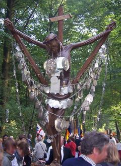
About Our Data
The data on this page is estimated using a number of publicly available tools and resources. It is provided without warranty, and could contain inaccuracies. Use at your own risk.