Postal Code 52353 - Düren, North Rhine-Westphalia
| Primary City | Düren |
| Area of Postal Code 52353 | 31.4 km² |
| Population | 28,841 |
| Male Population | 14,111 (48.9%) |
| Female Population | 14,730 (51.1%) |
| Population change from 1975 to 2015 | +1.5% |
| Population change from 2000 to 2015 | -4.4% |
| Median Age | 44.9 years |
| Male Median Age | 43.9 years |
| Female Median Age | 45.9 years |
| Area Codes | 2421 |
| Neighborhoods | Arnoldsweiler, Birkesdorf, Echtz, Hoven, Mariaweiler, Merken |
| Timezone | Central European Summer Time |
| Coordinates | 50.833556063481794° / 6.455015794699737° |
| Related Postal Codes | 52349, 52351, 52355, 52372, 52379, 52382, 52385, 52388, 52391, 52393 |
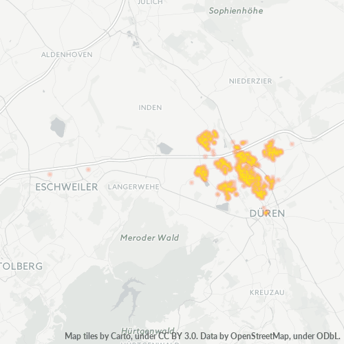
Map of Postal Code 52353 - Düren, North Rhine-Westphalia
Interactive Map
Postal Code 52353 - Düren, North Rhine-Westphalia Population
Years 1975 to 2020
| Data | 1975 | 1990 | 2000 | 2015 | 2020 |
|---|---|---|---|---|---|
| Population | 28,404 | 28,602 | 30,155 | 28,841 | 28,848 |
| Population Density | 903.2 / km² | 909.5 / km² | 958.9 / km² | 917.1 / km² | 917.3 / km² |
Postal Code 52353 - Düren, North Rhine-Westphalia Population change from 2000 to 2015
Decrease of 4.4% from year 2000 to 2015
| Location | Change since 1975 | Change since 1990 | Change since 2000 |
|---|---|---|---|
| Postal Code 52353 - Düren, North Rhine-Westphalia | +1.5% | +0.8% | -4.4% |
| Düren | -10.7% | -5.6% | -6.3% |
| North Rhine-Westphalia | +2.5% | +1.7% | -1.9% |
| Germany | +2.6% | +2.2% | -1.5% |
Postal Code 52353 - Düren, North Rhine-Westphalia Median Age
Median Age: 44.9 years
| Location | Median Age | Median Age (Female) | Median Age (Male) |
|---|---|---|---|
| Postal Code 52353 - Düren, North Rhine-Westphalia | 44.9 yrs | 45.9 yrs | 43.9 yrs |
| Düren | 44.9 yrs | 45.9 yrs | 43.9 yrs |
| North Rhine-Westphalia | 44.5 yrs | 45.6 yrs | 43.3 yrs |
| Germany | 44.8 yrs | 46 yrs | 43.6 yrs |
Postal Code 52353 Population Density
Population Density: 917 / km²
| Location | Population | Area | Density |
|---|---|---|---|
| Postal Code 52353 | 28,841 | 31.4 km² | 917 / km² |
| Düren | 69,694 | 31.7 km² | 2,197 / km² |
| North Rhine-Westphalia | 18.3 million | 34,118.6 km² | 537 / km² |
| Germany | 80.7 million | 358,179.8 km² | 225 / km² |
Postal Code 52353 - Düren, North Rhine-Westphalia Historical and Projected Population
Estimated Population from 0 to 2100
- JRC (European Commission's Joint Research Centre) work on the GHS built-up grid
- CIESIN (Center for International Earth Science Information Network)
- [Link] Klein Goldewijk, K., Beusen, A., Doelman, J., and Stehfest, E.: Anthropogenic land use estimates for the Holocene – HYDE 3.2, Earth Syst. Sci. Data, 9, 927–953, https://doi.org/10.5194/essd-9-927-2017, 2017.
Neighborhoods
Business Distribution by neighborhood in Postal Code 52353 - Düren, North Rhine-Westphalia
Industries
Business Distribution by Industry in Postal Code 52353 - Düren, North Rhine-Westphalia
| Industry Description | Number of Establishments | Average Age of Business |
|---|---|---|
| All food and beverage | 44 | — |
| Beauty salons | 37 | — |
| Car repair | 61 | — |
| Construction of buildings | 49 | — |
| Corporate management | 102 | 21.2 years |
| Electrical installation | 53 | — |
| Gas station | 37 | — |
| Hairdressers | 37 | — |
| Health and medical | 64 | — |
| Other membership organizations | 42 | — |
| Real estate | 57 | — |
| Restaurants | 98 | — |
| Shopping | 113 | — |
| Wholesale of machinery | 37 | — |
Human Development Index (HDI)
Statistic composite index of life expectancy, education, and per capita income.
Postal Code 52353 CO2 Emissions
Carbon Dioxide (CO2) Emissions Per Capita in Tonnes Per Year
| Location | CO2 Emissions | CO2 Emissions Per Capita | CO2 Emissions Intensity |
|---|---|---|---|
| Postal Code 52353 | 283,781 tn | 9.84 tn | 9,023.9 tons/km² |
| Düren | 685,908 tn | 9.84 tn | 21,626 tons/km² |
| North Rhine-Westphalia | 183,519,420 tn | 10.01 tn | 5,378.9 tons/km² |
| Germany | 755,339,039 tn | 9.36 tn | 2,108.8 tons/km² |
| 2013 CO2 emissions (tonnes/year) | 283,781 tn |
| 2013 CO2 emissions (tonnes/year) per capita | 9.84 tn |
| 2013 CO2 emissions intensity (tonnes/km²/year) | 9,023.9 tons/km² |
Natural Hazards Risk
Relative risk out of 10
| Hazard | Risk Level |
|---|---|
| Flood | Medium (7) |
| Earthquake | Medium (4) |
Recent Nearby Earthquakes
Magnitude 3.0 and greater
| Date▼ | Time↕ | Magnitude↕ | Distance↕ | Depth↕ | Location↕ | Link |
|---|---|---|---|---|---|---|
| 9/8/11 | 12:02 PM | 4.2 | 99.2 km | 6,000 m | Germany | usgs.gov |
| 4/11/10 | 4:16 AM | 3.4 | 82.2 km | 5,000 m | Germany | usgs.gov |
| 7/23/09 | 7:58 PM | 4.1 | 76.9 km | 5,000 m | Germany | usgs.gov |
| 12/25/08 | 5:53 AM | 3.2 | 78.3 km | 1,000 m | Germany | usgs.gov |
| 12/9/08 | 7:28 PM | 3.3 | 91.6 km | 10,000 m | Germany | usgs.gov |
| 11/21/08 | 11:41 PM | 3.3 | 85.9 km | 1,000 m | Germany | usgs.gov |
| 11/12/08 | 12:56 PM | 3.4 | 70.7 km | 1,000 m | Germany | usgs.gov |
| 9/18/08 | 7:33 AM | 3.2 | 87.2 km | 1,000 m | Germany | usgs.gov |
| 5/13/08 | 2:55 AM | 3.3 | 77.7 km | 1,000 m | Germany | usgs.gov |
| 5/1/08 | 11:54 PM | 3.1 | 78.9 km | 1,000 m | Germany | usgs.gov |
Primary City
Düren is a town in North Rhine-Westphalia, Germany, between Aachen and Cologne on the river Rur.
Düren Wikipedia Page
About Our Data
The data on this page is estimated using a number of publicly available tools and resources. It is provided without warranty, and could contain inaccuracies. Use at your own risk.