4,851 Postal Codes in Italy
The average area zip codes in Italy is 65.5 km² with the largest being 09010 at 1,640.6 km² and the smallest being 84023 at 31,542 m². In Italy the average population for a postal code is 12,975 with the most populated being zip code 81030 in Castel Volturno, Campania at 205,007. The median age for postal codes in Italy range from 28.6 years old for 89039 in Platì, Regione Calabria to 58.7 years old for 16020 in Gorreto, Liguria. The fastest growing postal code is 20877 in Roncello, Lombardia with population growth of 113.4% from 2000 to 2015, an average of 5.2% per year.
| Timezone | Central European Time |
| Area | 30,138 km² |
| Population | 60.3 million |
| Population Density | 2,002 / km² |
| Postal Codes | 00010, 00011, 00012 (4,848 more) |
| Area Codes | 10, 11, 121 (238 more) |
| Businesses in Italy | 3,551,604 |
| Cities | 2,520 |
Postal Code Ranges
| Postal Codes | Administrative Region | Number of postal codes |
|---|---|---|
| 00010 - 04100 | Lazio | 220 |
| 05010 - 06135 | Umbria | 80 |
| 07014 - 09170 | Sardinia | 98 |
| 10010 - 18025, 28016 - 28925 | Piedmont | 389 |
| 11013 - 11029 | Aosta Valley | 10 |
| 16013 - 19139 | Liguria | 160 |
| 20010 - 28819 | Lombardy | 615 |
| 30010 - 32100, 35010 - 37142 | Veneto | 284 |
| 33010 - 34170 | Friuli-Venezia Giulia | 104 |
| 38019 - 39100 | Trentino-Alto Adige/Südtirol | 103 |
| 40010 - 48125 | Emilia (region of Italy) | 292 |
| 50010 - 59100 | Tuscany | 265 |
| 60010 - 63900 | Marche | 170 |
| 64010 - 67100 | Abruzzo | 145 |
| 70010 - 76125 | Apulia | 124 |
| 80010 - 84135 | Campania | 247 |
| 86014 - 86170 | Molise | 51 |
| 87010 - 89900 | Calabria | 200 |
| 90010 - 98168 | Sicily | 229 |
Interactive Map
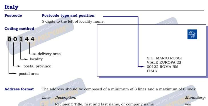
Address Example
4,851 Postal Codes in Italy
Italy
(Italian: Italia [iˈtaːlja]), officially the Italian Republic (Italian: Repubblica Italiana), is a unitary parliamentary republic in Europe. Italy covers an area of 301,338 km2 (116,347 sq mi) and has a largely temperate seasonal climate; due to it.. Italy Wikipedia Page